Foel Offrwm SOTA Activation

Summits On the Air Reference GW/NW-055, 1 point

Activity Summary

  • πŸ“… Date : 29th September 2026
  • πŸ“ Distance : 2.85 km
  • ⬆️ Ascent : 186 m
  • πŸ”οΈ Max Altitude : 405 m
  • ⏱️ Time to Summit : 0:34 hrs
  • πŸ• Total Activation Time : 1:55 hrs

Weather

  • ☁️ Cloudy
  • 🌑️ Temperature 12 ℃
  • 🌑️ Feels like 9 ℃
  • πŸ’§ Humidity 96%
  • πŸ’¨ Wind Speed 24 km/h
  • 🧭 Wind Direction ESE

Equipment Used

  • Icom IC705 (10w)
  • 2,500mAh LiFePO4 battery pack
  • 2m, flowerpot
  • SOTABEAMS Carbon 6 pole
  • PoLo logging app on iPad mini

Parking Location What3Words

///images.hikes.shuttle

Activation Report

I managed to find some time to get out on a SOTA activation. However, the weather on my local summits, above 600m, wasn’t looking great. So I opted for the lower summit of Foel Offrwm standing at 405m.

I arrived at the carpark, located at SH 74556 21179, at around 10:15 in the morning. The carpark is free and also has toilets.
It was 10:25, as I crossed over the road to join the track, and then followed the signs to Foel Offrwm. The path was straightforward, and it took me around half an hour to reach the summit. The summit was capped in cloud so I didn’t bother taking a video.
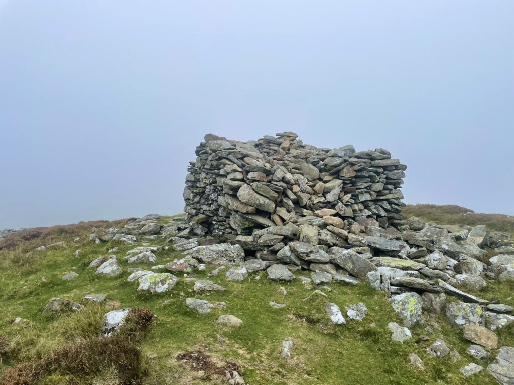
The summit folly

On the southwest side of the folly there was a perfect spot to set up my station. There were some stones that made a nice small stone seat, and luckily it was also on the leeward side of the folly.
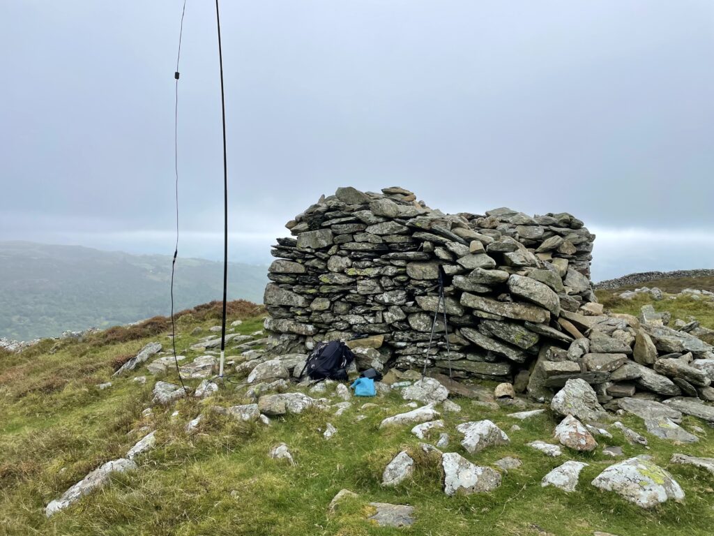
This picture taken as I had finished. The cloud had lifted

I started on 2m SSB with Don, Gw0PLP first in the log. After some swapping between 2m SSB and FM, I managed seven contacts including one dupe. I was happy with that for Tuesday morning on 2m, especially as this isn’t a great summit for VHF.
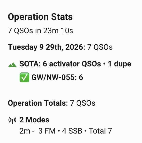
QSO summary

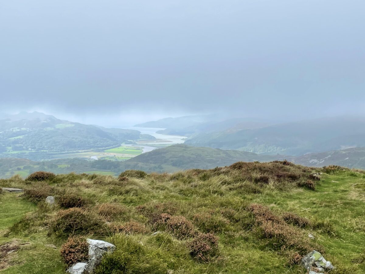
By the time I had started packing away the cloud was lifting and the Mawddach Estuary came into view. At least I had some views before descending back to the car.

The Mawddach estuary below.

I descended back to the carpark, that to my surprise, was full. It was empty when I started out a couple of hours earlier. This was a nice, reasonably quick one point activation, I will probably be doing more one pointers for the remainder of this year.


The interactive map below shows a track of the route taken. You can zoom in or out to change the scale. The route may contain errors and should be used only as a guide.

Download file for GPS

Further information can be found on the SOTA resource page for the summit

Esgeiriau Gwynion SOTA Activation

Summits On the Air Reference GW/NW-031, 4 points

Activity Summary

  • πŸ“… Date : 22nd July 2026
  • πŸ“ Distance : 8.02 km
  • ⬆️ Ascent : 210 m
  • πŸ”οΈ Max Altitude : 671 m
  • ⏱️ Time to Summit : 1:12 hrs
  • πŸ• Total Activation Time : 3:50 hrs

Weather

  • ☁️ Cloudy
  • 🌑️ Temperature 11 ℃
  • 🌑️ Feels like 10 ℃
  • πŸ’§ Humidity 81%
  • πŸ’¨ Wind Speed 5 km/h
  • 🧭 Wind Direction N

Equipment Used

  • Icom IC705 (10w)
  • 4000 mAh LiFePO4 battery pack
  • 2m, flowerpot
  • SOTABEAMS Carbon 6 pole
  • PoLo logging app on iPad mini

Parking Location What3Words

///nerves.amps.bordering

Activation Report

My plan for a busy month of activating during July hadn’t worked out, due to life having different ideas. The most notable life event was, unfortunately, having to say goodbye to our fifteen and a half year old Chocolate Labrador, Edward, on the 27th June. Our priority then shifted to helping our twelve year old Border Terrier adjust to being without his brother. In terms of SOTA, the Border is now too old for days in the hills, which limited my opportunities for activating.

Nearly four weeks after my last activation, I finally found a window to get back on the hills. It was about nine o’clock in the morning when I pulled into the Bwlch y Groes car park, and about 9:15 when I set off walking. Esgeiriau Gwynion was actually a summit on my ‘never to do again’ list, due to it still being boggy during last year’s dry spring. However, with the last few weeks of hot and dry weather, I suspected it may now be completely dry.

The information board in the car park

This route is normally very boggy, and mostly follows the fence line over peaty moorland. I was relieved to see that the peat hags were unusually dry for my visit. I was able to keep a straight path close to the fence, unlike my visit last year, when it was like solving a puzzle trying to find a suitable route around the boggy peat.

The unusually dry peat

After just over an hour, I had reached the summit. It’s one of those unassuming summits where you need to check the map to confirm you’re indeed on the summit. That said, you do get a good view of the Aran Fawddwy ridge line.

I set up my station a few metres to the south-west of the summit, in order to try to get an improved take-off on the slightly steeper slope. VHF contacts to the west of my operating position were going to be a challenge, due to the imposing ridgeline of Aran Fawddwy 200m above me.

My station for the activation

As usual, I started on 2m SSB, with Mark, G7SXR, first in the log, followed by five more contacts on SSB. This included a summit to summit with Gerald, MW0WML, on GW/SW-042. After switching to 2m FM, I managed three more contacts in the log, including a summit to summit with John, G4TQE, on GW/NW-060. After much calling on 144.300, I settled for the nine contacts and packed away.

QSO Map
QSO summary

I descended the same way I had come up, and seemed to get back to the car in no time. I was glad to have been able to get out again, but time will tell whether I can pull back my 1,000 activator point target by year end.

The interactive map below shows a track of the route taken. You can zoom in or out to change the scale. The map can also be shown in full screen. The GPX track can also be downloaded using the link below the map. The route may contain errors and should be used only as a guide.

Download file for GPS
Edward, January 2011 – June 2026

Further information can be found on the SOTA resource page for the summit

Moel Siabod SOTA Activation

Summits On The Air reference GW/NW-010, 8 points

Activity Summary

  • πŸ“… Date : 21st June 2026
  • πŸ“ Distance : 7.72 km
  • ⬆️ Ascent : 686 m
  • πŸ”οΈ Max Altitude : 873 m
  • ⏱️ Time to Summit : 2:02 hrs
  • πŸ• Total Activation Time : 5:12 hrs

Weather

  • β›… Partly Cloudy
  • 🌑️ Temperature 10 ℃
  • 🌑️ Feels like 8 ℃
  • πŸ’§ Humidity 76%
  • πŸ’¨ Wind Speed 6 km/h
  • 🧭 Wind Direction NE

Equipment Used

  • Icom IC705 (10w)
  • 2500 mAh LiFePO4 battery pack
  • 2m flowerpot antenna
  • SOTABEAMS Carbon 6 pole
  • PoLo logging app on iPad mini

Parking Location What3Words

///outlawing.prank.needed

Activation Report

As I drove towards Capel Curig, I could see that the summit of Moel Siabod was clear of any cloud and bathed in sunshine. I knew this was going to be a good morning for an activation. I approached the parking spot with some apprehension β€” it was a Sunday morning, and I hoped that 7:30 would be early enough to get a space. I sighed with relief as I pulled in behind one of only three cars, with plenty of space still to spare. The parking spot is located at SH 71569 57860 and it is free to park.

The parking spot in the layby

I was on my way at 7:45 am, passing over the footbridge at the head of the Llynnau Mymbyr. Clear of the footbridge, a rocky path climbs up through trees for about a kilometre, before reaching open countryside.


Once in open countryside you get the first glimpses of Yr Wyddfa (Snowdon) and its surrounding summits that form the horseshoe.

Yr Wyddfa (Snowdon) and its surrounding summits

After about two hours of walking I arrived on the summit to find just one other person there, the benefit of an early start. Moel Siabod is another summit with jaw-dropping views on a clear day. You can see the views for yourself in the 360Β° video below.


Here’s another video from my first activation of Moel Siabod a few years ago β€” more of those views, from a different visit.

After chatting to the other walker, and soaking up the views, I found a spot to set up my station. As this was going to be a VHF only activation, I tried to stay as high as I could, whilst being far enough away from the trig so as not to cause any problems for other walkers.

My station behind a rock again!

I started on 2m SSB but was struggling to get a spot out. Fortunately Don, GW0PLP, heard me calling. With Don in the log, he then kindly spotted me on SOTA watch.

Views across to Yr Wyddfa (Snowdon)

I managed five contacts on 2m SSB before changing to FM. With a bit of switching between FM and SSB I managed to get ten unique contacts in the log, including two summit-to-summits. It had been slow going for a Sunday morning, perhaps because I was out earlier than usual.

QSO summary
QSO Map

With no more callers, I packed away and enjoyed some more views before making my way down. On the descent there were great views looking across to Pen Llithrig y Wrach.

Pen Llithrig y Wrach can be seen in the distance.


Once back at the car, the layby was now full, as you would expect on a sunny Sunday. This was certainly one of my favourite activations of the year, although my list of favourites seems to grow with every summit.

The interactive map below shows a track of the route taken. You can zoom in or out to change the scale. The map can also be shown in full screen. The GPX track can also be downloaded using the link below the map. The route may contain errors and should be used only as a guide.

Download file for GPS

Further information can be found on the SOTA resource page for the summit

Y Garn SOTA Activation

Summits On The Air reference GW/NW-037, 4 points

Activity Summary

  • πŸ“… Date : 8th June 2026
  • πŸ“ Distance : 7.35 km
  • ⬆️ Ascent : 585 m
  • πŸ”οΈ Max Altitude : 629 m
  • ⏱️ Time to Summit : 1:56 hrs
  • πŸ• Total Activation Time : 4:33 hrs

Weather

  • 🌀️Partly cloudy
  • 🌑️ Temperature 9 ℃
  • 🌑️ Feels like 6 ℃
  • πŸ’§ Humidity 75%
  • πŸ’¨ Wind Speed 14 km/h
  • 🧭 Wind Direction W

Equipment Used

  • Icom IC705 (10w)
  • 4000 mAh LiFePO4 battery pack
  • 2m, flowerpot
  • SOTABEAMS Carbon 6 pole
  • PoLo logging app on iPad mini

Parking Location What3Words

///struck.adhesive.typist

Activation Report

With Mrs PDV working away in foreign climes, I had grand plans for a busy week of activating. That was, of course, until I looked at the weather forecast. Various combinations of strong winds and rain were forecast for the week, and things weren’t looking promising. Then, finally, a window of reasonable weather appeared for Monday.

I set off a little later than usual to avoid the early morning showers. It was 10:15 am, when I arrived at the National Trust carpark in the village of Ganllwyd. The location is SH 72683 24354. The carpark has toilets and is free, although they do ask for Β£1 donation.

The carpark behind the toilet block, easily missed as you drive in

I set off around 10:30, just as the last of the showers passed through. I crossed the road, passing the waterfall that is adjacent to the road. The force of the water was a reminder of how much rain there has been in the previous few days.

The falls were much tamer on previous visit a year ago

I made my way up through the woods, the path looked more like a stream in places. Once clear of the woods, you reach an area where gold mining was once prevalent. Several old buildings once part of the old gold mines remain. At the end of track located at SH 71605 22963, the path climbs up through open moorland. There is one point where you cross a small stream. As this is crossed, there is about a 2m climb up requiring the used of hands.

A little further on, a stile crosses a wall. From here there is a faint path heading to the summit. After about two hours of walking, I arrived on the summit with views across the Mawddach estuary.

I setup my station just below the summit cairn and got down to business, starting on 2m SSB.

My operating location.

Don, GW0PLP was first in the log. He had been following my APRS tracker and was waiting for me when I turned on my radio. I managed another four contacts on SSB, but did have to call on 144.300 to log the final two. Changing to 2m FM yielded two more, including Mark, M7DBF who just caught me as I was about to go QRT.

QSO map
Operation stats

I was pleased that I had managed to complete the activation, without any rain. Although, as I looked up, a dark cloud cast a shadow across the valley floor below me. Fortunately, it was moving away from me.

I thought a shower was incoming, but it was moving away from me.

I packed away and headed back down to the car, happy that I had managed to get out on an activation.

The interactive map below shows a track of the route taken. You can zoom in or out to change the scale. The map can also be shown in full screen. The GPX track can also be downloaded using the link below the map. The route may contain errors and should be used only as a guide.

Download file for GPS

Further information can be found on the SOTA resource page for the summit

Carnedd y Filiast SOTA Activation

Summits On The Air Reference GW/NW-032, 4 points

Activity Summary

  • Date : 30th April 2026
  • Distance : 11.98 km
  • Ascent : 576 m
  • Max Altitude : 669 m
  • Time to Summit : 0:38 hrs (eMTB)
  • Total Activation Time : 2:04 hrs

Weather

  • Clear
  • Temperature 9 ℃
  • Feels like 7 ℃
  • Humidity 69%
  • Wind Speed 16 km/h
  • Wind Direction ESE

Equipment Used

  • Icom IC705 (10w)
  • 4000 mAh LiFePO4 battery pack
  • 2m, flowerpot
  • SOTABEAMS Carbon 6 pole
  • PoLo logging app on iPad mini

Parking Location What3Words

///represent.vies.invents

Activation Report

This activation report for Carnedd y Filiast is the first of two SOTA activation reports for the day, see the separate report for Foel Cedig. For a change I was using my e-mountain bike to access the summit. Walking to the summit of Carnedd y Filiast is a bit of a slog. However, there is a well defined track that goes all of the way to the summit and so it lends itself to using a mountain bike.
I arrived at the parking spot by the side of the A4212, at about 8:20, the location of the parking is SH 86251 41145. This is conveniently located near the start of the track and so completely avoids the need to ride or walk on the main road. I started riding up the track at about 8:40, on what was a nice spring morning. It was nice to be out on a bike again as my mountain biking has mostly been on the back burner for the last 18 months, as I have been focusing on SOTA activating. Now for those who may be wondering, it is without doubt easier on an eMTB than a standard mountain bike. However, it still requires significant effort. For example, on this ascent my average power input was a 150 watts with peaks of 300 watts on steeper sections.

The summit with the trig pillar inside the shelter

After 38 minutes of riding, I arrived on a clear summit. There was some wind but it wasn’t a problem when sheltered behind the summit shelter. It was one of those glorious days with amazing views that reminds us why we slog up these hills.

Normally for a mountain bike activation, ebike or a normal full suspension bike, I would opt for the QMX and a handheld combination. But today I was using the IC705, as I am really enjoying the SOTA 2m SSB challenge this year. Because I had an HF antenna and a handheld as backup, my pack was 8 kilos. Not heavy for a hiking rucksack, but definitely on the heavy side for mountain biking.

I deployed the 2m flowerpot antenna on the carbon 6 pole and got down to business.

My sheltered location for the activation

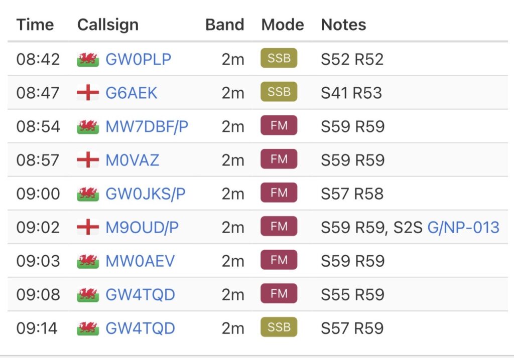
I was conscious that I was much earlier than my original alert on SOTA watch, and so I was thankful to hear the regular callers start to trickle in after my spot on 2m SSB. After only two contacts on SSB, I called on 144.300, but that didn’t yield any more callers, and so switched to 2m FM. I managed five more contacts on FM, including a summit to summit with Tony, M9OUd on The Calf, G/NP-013. I switched back to 2m SSB and managed another contact before packing up.

QSO summary
Activation log

The descent was very enjoyable although, I was soon feeling the extra pack weight in my legs whilst out of the saddle. Luckily the descent only took 19 minutes to get back to the car.

I had an early lunch in the car before driving the 30 minutes journey to the parking spot for my next activation of the day, Foel Cedig.

The interactive map below shows a track of the route taken. You can zoom in or out to change the scale. The map can also be shown in full screen. The GPX track can also be downloaded using the link below the map.

Download file for GPS

Further information can be found on the SOTA resource page for the summit